
70 products
Garmin Flush Mount Kit, Echomap 4x
010-12199-01
Regular price $14.99 Save $0.00Garmin Marine Mast Mount
010-11441-10
Regular price $24.99 Save $0.00
Garmin Marine Mast Mount, GPS12H/73 010-11441-10 Color: Black
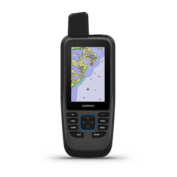
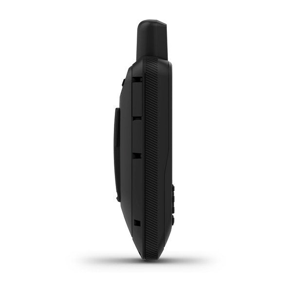
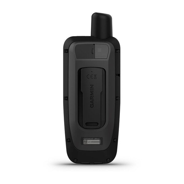
GPSMAP 86sc
010-02235-02
Regular price $449.99 Save $0.00
| PHYSICAL DIMENSIONS | WxHxD: 2.65" x 7" x 1.7" (6.75 x 17.8 x 4.4 cm) |
|---|---|
|
DISPLAY SIZE |
1.5"W x 2.5"H (3.8 x 6.3 cm); 3" diag (7.6 cm) |
| DISPLAY RESOLUTION | 240 x 400 pixels |
| DISPLAY TYPE | transflective, 65K color TFT |
| WEIGHT |
9.59 oz (272 g) |
| BATTERY TYPE | rechargeable internal lithium ion |
| BATTERY LIFE | Up to 40 hours (standard mode); up to 200 hours (expedition mode) |
| WATER RATING | IPX7 |
| HIGH-SENSITIVITY RECEIVER | |
| MEMORY/HISTORY | 16 GB |
GPSMAP 86sci, NA
010-02236-02
Regular price $649.99 Save $0.00Cast off confidently with GPSMAP¨ 86s. This premium, floating handheld has a sunlight-readable 3Ó color display plus support for optional BlueChart¨ g3 charts. Wireless connectivity makes it a virtual extension of your onboard marine system, allowing you to display boat data from compatible chartplotters and instruments. GPSMAP 86s also functions as a remote control for convenient operation of your Garmin autopilot and FUSION¨ marine products. Its adjustable GPS filter smooths speed and heading indications over swells, and it shows smart notifications when paired with a compatible smartphone. The internal, rechargeable lithium battery provides up to 40 hours of operation in standard mode and up to 200 hours in expedition mode.
microSDª Card Door 12" - Echomap Ultra
010-12842-04
Regular price $5.99 Save $0.00Keep your compatible marine device at sea by securing and protecting your memory card with this microSD door.
Compatible Devices:
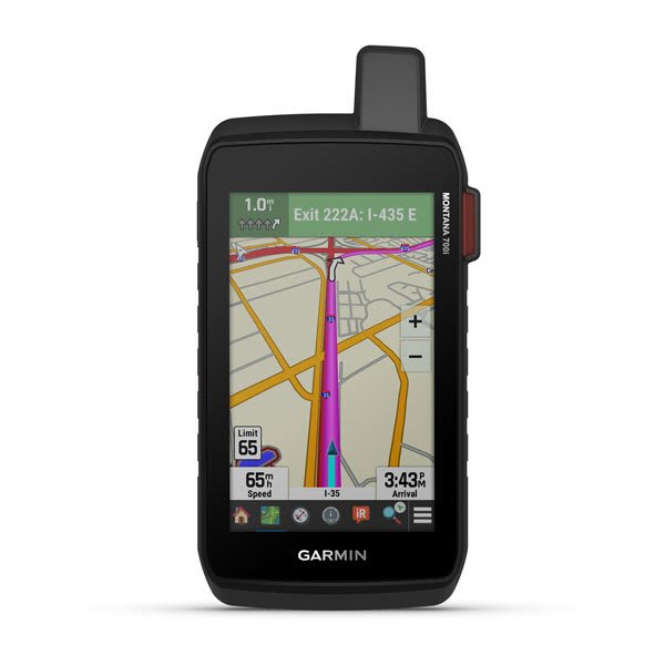
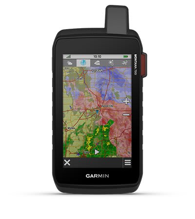
Montana 700i, US/Can TopoActive
010-02347-10
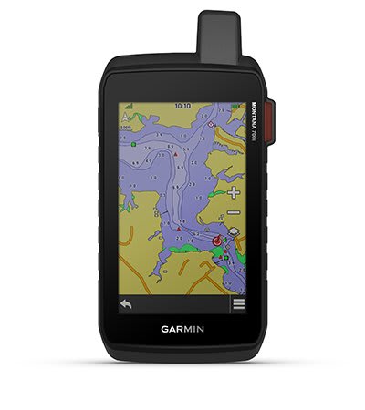
Regular price $699.99 Save $0.00To keep adventurers in touch and on track, the Montana 700i handheld combines the flexibility of on- or off-road navigation with global messaging and interactive SOS via inReach satellite technology1.
Big news. A full QWERTY keyboard lets you easily type messages.
Wander wider and still stay in touch — with inReach for messaging and 24/7 SOS.
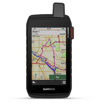
Routable topographic maps? Check. Now you’re free to take it off-road or on.
Built like a tank. Meets MIL-STD 810 for thermal, shock, water and vibration.
Get the clear perspective of BirdsEye Satellite Imagery right to your device.
Power your adventures with 18+ hours of lithium-ion battery life in GPS mode.

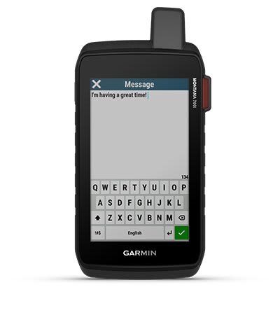
Exchange text messages with loved ones, post to social media, or communicate via inReach device to inReach device in the field (active satellite subscription required).
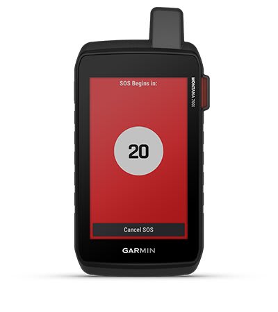
In case of emergency, trigger an interactive SOS message to GEOS, the Garmin-powered International Emergency Response Coordination Center (IERCC) with professional 24/7 global monitoring and response center (active satellite subscription required).
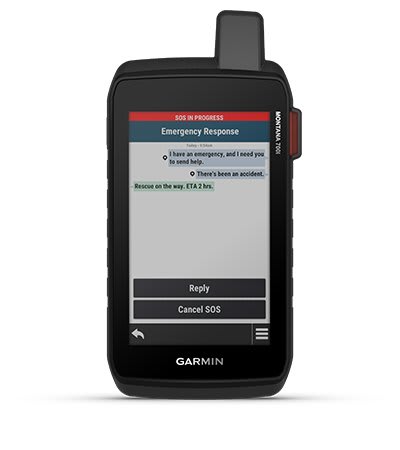
Instead of relying on cellphone coverage, now your messages, SOS and tracking are transferred via the 100% global Iridium® satellite network (active satellite subscription required).
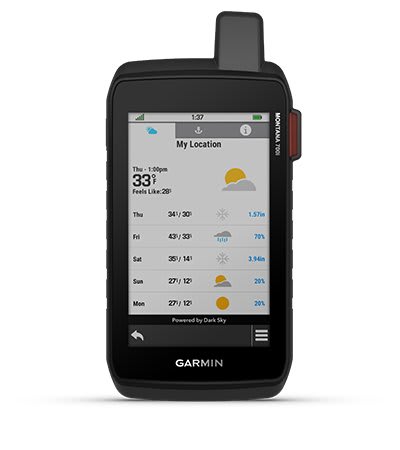
Available inReach weather forecast service provides detailed updates directly to your Montana handheld or paired devices, so you’ll know what to expect en route.
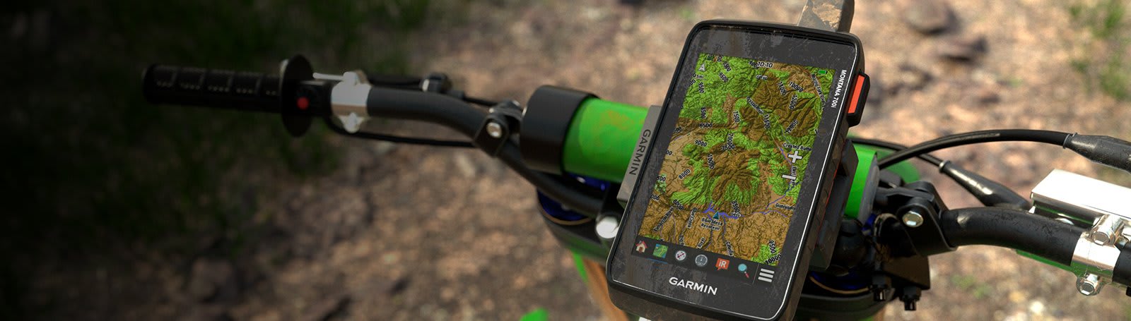
This durable, water-resistant handheld is tested to U.S. military standards and features a glove-friendly 5” touchscreen that’s 50% larger than previous Montana models.
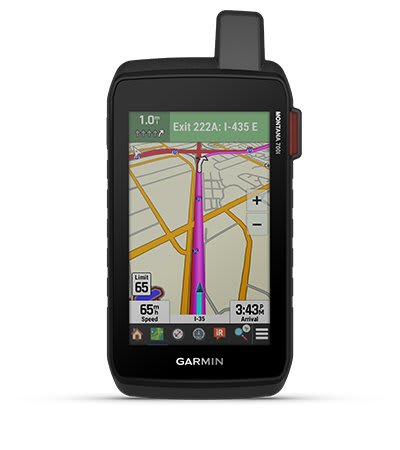
Seamlessly transition from trails to road navigation with preloaded City Navigator street mapping, which guides your drive with easy-to-follow turn-by-turn directions.
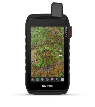
To navigate your adventures, use preloaded topographical maps for the U.S. and Canada. View terrain contours, elevations, coastlines, rivers, landmarks and more.
With 16 GB of onboard memory and a microSD™ card slot for expandable storage, you can download even more maps such as BlueChart® g3 for the water.
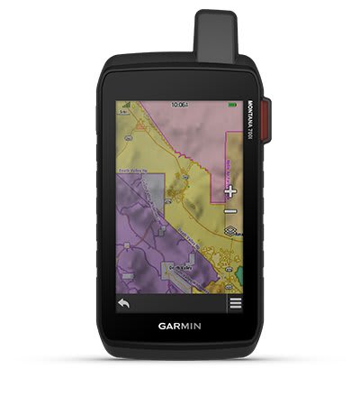
Optional display of federal public land boundaries on topographical maps helps you know that you’re venturing where you’re supposed to be.
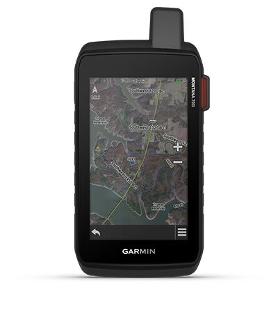
Use direct-to-device downloads of BirdsEye Satellite Imagery (no annual subscription required) to see photo-realistic views and create waypoints based on landmarks.
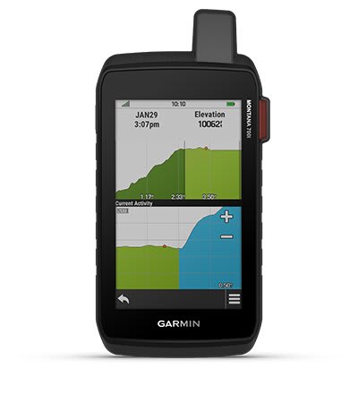
Navigate your next trail with ABC sensors, including an altimeter for elevation data, barometer to monitor weather and 3-axis electronic compass.
Use cellular connectivity2 to access up-to-date Active Weather forecasts through the Garmin Connect™ app.
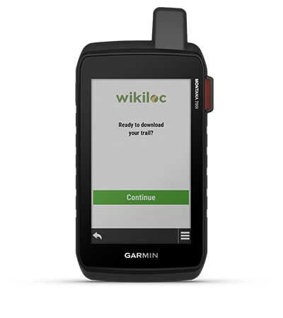
This preloaded app lets you easily download hiking, cycling and other Wikiloc trails shared by outdoor enthusiasts like you. Get a free 60-day Wikiloc Premium trial to try this and other exclusive features. Learn more.

Access to both GPS and Galileo satellite networks enables Montana 700i to track in more challenging environments than GPS alone.
Using your web-based MapShare™ trip-sharing page, followers can see your progress, ping your device to see your GPS location and exchange messages during your trip.
Trek far and wide off-grid. Use Expedition mode, an ultralow-power GPS reference, to keep Montana tracking for a week or more between recharges.
An internal, rechargeable lithium-ion battery pack provides more than 18 hours of battery life in GPS mode.
A variety of Montana handheld-compatible mounts (sold separately) lets you adapt your navigator for use on ATVs, boats, cars, motorcycles, RVs or other vehicles.
Sign up to our newsletter for exciting news on product launches, special promotions, events and more.